How to Conduct a Comprehensive Geotechnical Site Investigation in Bali to Reduce Construction Risks
Januari 10, 2026 | by Admin

Understanding the Importance of Geotechnical Investigations in Bali
Bali, known for its breathtaking landscapes and unique topography, presents both opportunities and challenges for construction projects. The island’s diverse geological features, including volcanic soils, varying elevations, and potential slope instability, necessitate a thorough understanding of the subsurface conditions before any development begins. A comprehensive geotechnical site investigation is crucial to identify potential risks such as soil bearing capacity, groundwater levels, and slope stability, ensuring that construction projects are safe, sustainable, and compliant with engineering standards.
Key Components of a Geotechnical Site Investigation in Bali
Conducting a geotechnical site investigation in Bali involves several critical steps, each designed to gather detailed data about the ground conditions. These components include:
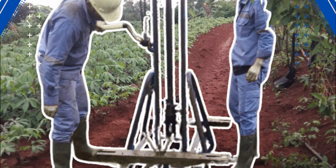
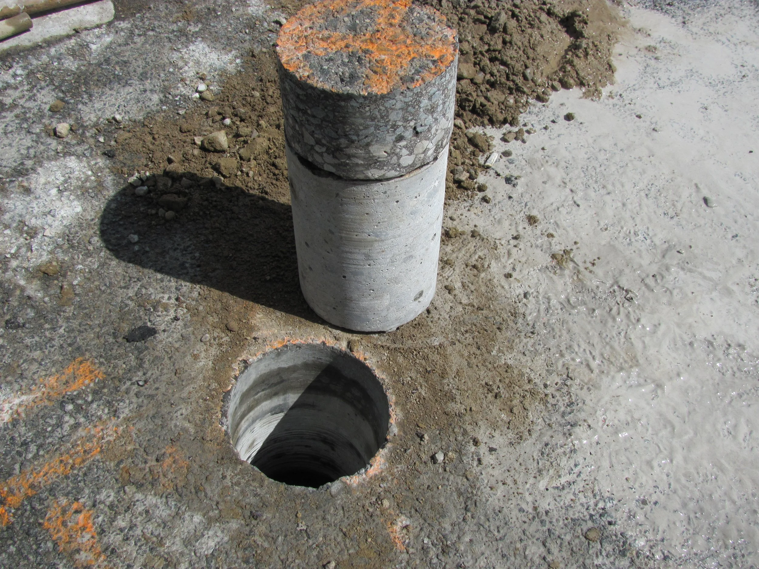
Borehole Drilling: This process involves drilling into the ground to collect soil samples at various depths. Boreholes can reach depths of up to 30 meters, providing valuable insights into the soil composition and stratification.
Standard Penetration Testing (SPT): SPT is a common method used to determine the relative density and strength of soil layers. By measuring the resistance of the soil to penetration, engineers can assess the bearing capacity and suitability of the ground for different types of foundations.
Cone Penetration Testing (CPT): CPT provides continuous data on soil resistance and strength, offering a more detailed analysis of the subsurface conditions. This method is particularly useful in identifying variations in soil properties across the site.
Topographic Survey: A topographic survey maps the elevation changes and natural features of the land. This information is essential for planning construction activities, determining drainage systems, and assessing the impact of terrain on building design.
Slope Stability Analysis: In areas with steep slopes, such as Petang in Badung, slope stability analysis is vital. This involves evaluating the risk of landslides and determining the necessary reinforcement measures to ensure the safety of structures.
Field Testing and Methodology

In Bali, field testing is often conducted using a combination of methods to ensure accurate and reliable results. For instance, in the Desa Carang Sari area, Indo Soil conducted a series of tests that included:
- 4 Boreholes reaching depths of up to 30 meters, with Standard Penetration Testing (SPT) to assess soil strength.
- 3 Cone Penetration Tests (CPT/Sondir) to evaluate cone resistance and local shear strength.
- Topography Survey to determine elevation gradients and understand the land’s contours.
- Slope Analysis on 4 cross-sections near borehole locations to assess the stability of the terrain.
This multi-layered approach is essential in areas with complex soil layers and undulating topography, ensuring that all potential risks are identified and addressed.
Soil Findings and Recommendations
The soil investigation in Desa Carang Sari revealed a mix of clay loam, marine clay, and young sedimentary rock (cadas muda) at deeper levels. The top layers ranged from soft to medium consistency, gradually transitioning into harder strata suitable for anchoring foundations. The SPT results showed increasing N-values with depth, indicating improving soil strength below 5 meters. Most boreholes hit stiff soil and rock layers between 9–11 meters, making bore piles a suitable recommendation for foundation design.
Groundwater levels were also assessed, and no significant groundwater table was encountered within the tested depth (up to 30 meters), minimizing concerns for water intrusion or buoyancy effects during foundation placement.
Foundation Design and Topographic Considerations
Based on the borehole and CPT data, the recommended bearing capacities for 30 cm diameter bore piles were within the range of 50–56 tons, depending on the location and depth. This makes bore piles ideal for supporting mid-rise villas, small resorts, or other residential buildings expected in this area. For shallow footings, allowable bearing capacities at 1–1.5 meters ranged between 0.5–1.3 kg/cm², which may be suitable only for lightweight structures.
Topographic surveys revealed gentle to moderate slope variation across the site. These changes in elevation were taken into account during the slope section analysis. While overall terrain appeared manageable for residential construction, localized grade changes above 15% would require proper retaining structures and drainage systems to prevent erosion or sliding.
Slope Stability and Risk Mitigation
Slope stability analysis is a critical component of any geotechnical investigation, especially in high-rainfall areas like Petang. Four slope sections were analyzed using borehole and soil strength data, and all four sections produced stability factors above the minimum threshold for safe construction. However, reinforcement and drainage systems are recommended in steeper zones to mitigate the risk of landslides and ensure long-term stability.
Conclusion and Next Steps
A comprehensive geotechnical site investigation in Bali provides a solid foundation for any construction project. By understanding the subsurface and surface conditions, developers can make informed decisions about foundation design, structural stability, and risk mitigation. The data gathered from these investigations is invaluable for ensuring that projects are built safely and sustainably, adhering to engineering standards and local regulations.
For those planning developments in Bali, partnering with experienced professionals who specialize in geotechnical investigations is essential. Companies like Indo Soil offer expert services tailored to the unique challenges of Bali’s landscape, ensuring that every project starts with accurate and reliable ground data.
[IMAGE: Geotechnical Site Investigation in Bali to Minimize Construction Risks]
PT Anggarda Paramita Engineering adalah perusahaan konsultan profesional yang bergerak di bidang survey topografi, geoteknik, dan geolistrik, melayani kebutuhan pemetaan lahan, analisis struktur tanah, serta identifikasi kondisi bawah permukaan untuk berbagai proyek konstruksi dan infrastruktur.
Jakarta
Jl. Raya Pasar Minggu, Lenteng Agung, Jakarta Selatan.
Bali
Perumahan Umasari Gg Mungil , Kerobokan, Petitenget, Denpasar.
Services
Catatan Penting
- Pengetesan Tanah dengan Sondir
- Building Paradise: The Ultimate Guide to Hiring a Bali Bamboo Villa Contractor
- Dasar Ilmu Teknik Geofisika
- Apa Itu Survey Batimetri ? Fungsi, Metode, dan Manfaatnya
- Bali Contractor Villa
- Survey Ukur Tanah Jakarta
- CPT Test (Sondir Tanah) : Langkah Penentu Rencana Pondasi
- Apa Itu Jasa GPR Georadar ? Penjelasan Lengkap Teknologi Jasa GPR Georadar
- Mending Sewa GPR atau Pake Jasa Konsultan Geo Radar ?
- Perusahaan Jasa Survei Geolistrik
- Jasa Surveyor Pengukuran Topografi
- Ngobrolin Jasa Survei Topografi
- Analisis Laboratorium Boring Tanah
- Alat Geolistrik dan Fungsinya
- Cara Ambil Data Topografi
- Test Tanah untuk Pondasi Itu Wajib, Bukan Cuma Formalitas
- PT Anggarda Paramita Engineering: Pioneers in Soil Investigation Services in Denpasar
- Survey Topografi untuk Konstruksi
- Akurasi Pengukuran Jarak Miring
- Alat Pemetaan Topografi Modern
- Geolistrik: Teknologi Canggih untuk Mencari Sumber Air Tanah yang Efisien
- Fungsi Total Station Adalah Kunci Utama Pengukuran Modern
- Soil Testing Service Denpasar
- Pengukuran Topografi Menggunakan RTK
- Alat Geolistrik Modern dan Canggih
- Professional Geotechnical Testing Services in Bali: Ensuring Safe and Reliable Construction Projects
- Jasa Konsultan Lingkungan Hidup
- Analisa Geoteknik Perencanaan Struktur
- Metode Geolistrik Schlumberger: Teknik Terbaik untuk Eksplorasi Bawah Tanah
- Pentingnya Survei Topografi Lahan
- Jasa Konsultan Sondir Tanah
- Apa Itu Peta Topografi?
- How Professional Geotechnical Surveys Help Reduce Construction Risks in Bali
- Biaya Pengecekan Geolistrik Air : Worth It Nggak Sih Buat Cari Sumber Air?
- Overcoming Geotechnical Challenges in South Denpasar: Solutions for Sandy and Marshy Terrain
- Understanding CPT vs. SPT: Which Soil Test Does Your Denpasar Project Need?
- Data Lengkap Survey Topografi
- Metode Geolistrik Konfigurasi Wenner: Pengertian, Kelebihan, dan Penerapan dalam Eksplorasi Bawah Tanah
- Peran Survey Topografi Penting
- Soil Testing in Buleleng : The Ultimate Guide to Geotechnical Investigation in North Bali
- Teknologi Menggali Misteri Dalam Tanah: Kekuatan Inovasi di Balik Permukaan Bumi
- Understanding the Importance of Geotechnical Reports for Building Permits in Bali
- Survey Geolistrik untuk Pertanian : Mencari Sumber Air di Lahan Kering
- Jasa Boring Tanah Denpasar
- Geolistrik untuk Bidang Pertambangan
- Dasar Penting Sondir Tanah
- Cara Test Kekuatan Tanah yang Efektif dan Akurat untuk Konstruksi
- Jasa Konsultan Perencanaan Proyek
- Pengujian Kekuatan Tanah: Pentingnya dalam Konstruksi dan Perencanaan Bangunan
- Jasa Konsultan Perencana Proyek
- Kelebihan Konfigurasi Schlumberger yang Harus Anda Ketahui
- Apa itu Sondir Tanah (CPT) ?
- Bagaimana Cara Kerja Alat Sondir (Cone Penetration Test / CPT)
- Aplikasi Survei Topografi Terkini
- Survey Topografi agar Perencanaan Efektif
- Cara Kerja Geolistrik Air Tanah untuk Pemula yang Mudah Dipahami
- Deteksi Kedalaman Lapisan Akuifer
- Aplikasi Geolistrik untuk Industri
- Aplikasi Metode Geolistrik dalam Berbagai Bidang yang Menarik dan Berguna
- Analisis Geoteknik untuk Keberlanjutan
- Jasa Geolistrik Profesional Terbaik untuk Solusi Pengujian Tanah yang Akurat dan Handal
- Metode Geolistrik untuk Eksplorasi Air Tanah: Teknik Terbaru dan Manfaatnya
- Jasa Konsultan Georadar
- Cara Mudah Menggunakan Geolistrik untuk Menemukan Sumber Air Tanah
- Teori dan Aplikasi Metode Geolistrik Resistivitas dalam Penyelidikan Bumi
- Analisis Penetrasi Konus CPT
- Deteksi Mineral dengan Geolistrik : Cara Kekinian Cari Harta Karun Bawah Tanah
- Bedanya Surveyor Biasa dan Konsultan Survei Pemetaan Profesional : Apaan Sih?
- Geolistrik Dipole Dipole: Teknik Pengukuran dan Penerapan dalam Eksplorasi Bawah Tanah
- How Geotechnical Testing Services in Bali Enhance Structural Safety and Longevity
- Geolistrik Inovasi dalam Eksplorasi
- Kelebihan Jasa Georadar Dibandingkan Metode Konvensional
- Alat Survey Topografi Lengkap
- Data Akurat Survei Topografi — Biar Gak Salah Gali!
- Aplikasi Metode Geolistrik dalam Pertambangan untuk Pemetaan Bawah Tanah yang Lebih Akurat
- Bali Bamboo Villa Design: A Complete Guide to Natural & Sustainable Architecture
- Why PT Anggarda Paramita Engineering is Denpasar’s Top Choice for Accurate Soil Testing
- Alasan Menggunakan CPT SPT
- Teknik Survey Topografi Modern
- Cara Ukur Total Station
- Biaya Survey Geolistrik Kompetitif : Gak Bikin Kantong Kering Buat Eksplorasi Bawah Tanah
- Ahli Geoteknik Profesional Indonesia
- Jasa Konsultan Pengawas Proyek
- Sondir Tanah Cepat dan Efisien
- Metode Analisis Stabilitas Pondasi
- Jasa Geolistrik Air Tanah : Solusi Cepat dan Akurat untuk Pencarian Sumber Air Bawah Tanah
- Pencarian Air Tanah Geolistrik
- Geolistrik Survei Air Tanah
- Pahami CPT Daya Dukung Tanah : Penting Banget Buat Proyek Konstruksi!
- Mengapa Konsultan Jasa Georadar1 dalam Proyek Konstruksi itu Penting?
- Belajar dari Proyek Villa Lovina : Mengapa Soil Test di Buleleng Sangat Vital untuk Lahan Bekas Sawah
- Metode Geolistrik Konfigurasi Wenner Schlumberger untuk Pemetaan Bawah Tanah yang Akurat
- Konfigurasi Schlumberger PDF: Panduan Lengkap untuk Pemula
- Jasa Geolistrik Di Malang Untuk Pemetaan Bawah Tanah yang Akurat dan Efisien
- Drone dalam Pemetaan Lahan
- Memilih Jasa Konsultan Georadar Profesional untuk Hasil Optimal
- Analisis Sondir Tanah Proyek
- Metode Geolistrik Aktif dan Pasif: Perbedaan, Kelebihan, serta Penerapan dalam Eksplorasi Bawah Tanah
- Langkah-langkah Survei Lahan Bersama Jasa Survei Topografi Tepat
- Expert Soil Investigation for Safe and Sustainable Bali Coastal Developments
- Jasa Perhitungan Struktur Bangunan
- Cost-Efficient Foundation Design: The Role of Accurate CPT Testing in Bali
- Teknik Survei Topografi Canggih
- Testimoni Klien: “Tanpa Survei Ini, Kami Gagal Bor Dua Kali!”
- Mengulik Eksplorasi Batubara & Logam
- Survey Geolistrik di Lokasi Sulit, Hasil Tetap Akurat!
- 10 Langkah Survei Topografi
- Alat Survey Geolistrik Modern
- Boring Tanah untuk Pondasi
- Solusi Geolistrik Terkini untuk Proyek Geothermal dan Energi Baru yang Berkelanjutan
- Apa sih Konsultan Pemetaan Topografi Tanah ?
- Reliable Geotechnical Engineering in Denpasar: Expert CPT and SPT Services for Safe Construction
- Prinsip Metode Kerja Geolistrik
- Cara Mengukur Volume Tanah
- Dasar Survei Topografi Proyek
- Cek Kestabilan Tanah Konstruksi
- Teknologi Geolistrik Membuka Peluang Masa Depan yang Lebih Cemerlang
- Geolistrik Adalah Inovasi Penyelidikan
- Aplikasi Geolistrik dalam Pertambangan
- Jasa Konsultan Perencana Infrastruktur
- Jasa Geolistrik Kota Bandung : Solusi Terbaik untuk Pemetaan Bawah Tanah
- Konsultan Soil Test Tanah
- Dasar Survei Topografi Proyek
- Dokumentasi As-Built Pekerjaan Lapangan
- Soil Testing Best Practices for Large-Scale Hotel Developments in Bali
- Jasa Konsultan Pengawasan Proyek
- Eksplorasi Sumber Panas Bumi
- Top-Rated Soil Test Services in Denpasar: CPT & SPT by PT Anggarda Paramita Engineering
- Jasa Survey Topografi Tanah
- How to Conduct a Comprehensive Geotechnical Site Investigation in Bali to Reduce Construction Risks
- Survey Geolistrik untuk Sumur Bor: Langkah Cerdas Sebelum Pengeboran
- Aplikasi Survey Topografi Digital
- How Soil Testing Prevents Foundation Failure: Insights from Denpasar Engineers
- Analisa SPT Proyek Infrastruktur
- Cara Kerja Geolistrik dan Manfaatnya dalam Eksplorasi Bumi
- Cara Test Kekuatan Tanah
- Alat Pemetaan Digital Modern
- Jasa Boring Tanah SPT
- Analisis Tanah untuk Konstruksi
- Biaya Geolistrik Air Tanah yang Perlu Anda Ketahui Sebelum Memulai Proyek
- Biaya Uji Geolistrik Profesional yang Perlu Anda Ketahui
- How to Maximize Building Safety in Denpasar Using High-Precision SPT Data
- Apa Itu Survey Geolistrik?
- Tips Survey Topografi Jembatan
- From CPT Data to Solid Foundations: Engineering Excellence in Denpasar
- The Hidden Map Beneath Your Feet: The Ultimate Guide to Geoelectric Tests in Bali
- Memahami Data Laporan Geolistrik
- Survey Topografi Guna Pemetaan Lahan
- Jasa Geolistrik Terpercaya di Surabaya untuk Proyek Konstruksi yang Akurat dan Efisien
- Survey Multi-Titik untuk Developer Properti: Strategi Efektif Meningkatkan Kualitas Proyek Perumahan
- Biaya Geolistrik Air Tanah
- Konsultan CPT Sondir Tanah : Langkah Kecil yang Nentuin Fondasi Besar
- Metode Sounding Geolistrik Resistivitas
- Tenang Air Bersih Bisa Ditemukan dengan Teknologi Geolistrik
- Mencari Sumber Air Bersih
- Aplikasi Modern Survei Geolistrik
- Konsultan Jasa Georadar : Solusi Akurat Deteksi Utilitas Bawah Tanah
- Analisis Tanah Rencana Pondasi
- Alat Geolistrik Portable Praktis
- Memahami Proses Sondir Tanah
- Klien Kami di Daerah Tandus Kini Punya Sumur Aktif
- Metode Geolistrik Konfigurasi Dipole Dipole dalam Penelitian Bawah Tanah
- A Step-by-Step Guide to Standard Penetration Testing (SPT) in Denpasar Construction Projects
- Membangun Masjid Bukan Sekadar Bangunan : Menyulam Doa, Kenyamanan, dan Keindahan bersama Jasa Arsitek Masji
- Jasa Geolistrik Terpercaya di Pekanbaru untuk Kebutuhan Survey dan Analisis Tanah
- Why Precise Soil Analysis is Critical for Infrastructure Stability in Denpasar
- Test Sondir Tanah : Pentingnya dalam Proyek Konstruksi dan Pengambilan Keputusan Teknis
- Biaya Jasa Geolistrik Bandung Terjangkau dan Akurat untuk Proyek Anda
- Jasa Konsultan Perencana Bangunan
- Sondir Tanah adalah Penyelidikan Penting
- Alat yang Dipergunakan oleh Surveyor Jasa Ukur Tanah
- The Importance of Cone Penetration Testing (CPT) for Bali’s Unique Soil Profiles
- Metode Geolistrik Yang Efektif
- Pengetesan Kekuatan Tanah : Pentingnya dalam Konstruksi dan Perencanaan Bangunan
- Survey Geolistrik untuk Area Perbukitan di Kota Bandung
- Data Sondir Tanah Akurat
- Kelebihan dan Kekurangan Konfigurasi Schlumberger yang Perlu Anda Ketahui
- Cara Membaca Hasil Uji Tanah yang Benar dan Akurat untuk Pertanian Sukses
- Geolistrik: Deteksi Bawah Permukaan
- Sondir Tanah Yang Cepat Efisien
- Pondasi dan Jenis Tanah yang Cocok untuk Bangunan Tahan Lama
- Biaya Survey Air Tanah
- Metode Geolistrik Air Tanah
- Analisis Data Geolistrik Resistivitas
- Analisis Geoteknik untuk Rencana Pondasi
- Teknik Sondir Tanah Modern
- Investigasi Tanah Boring Dalam
- Mengenal Prosedur Boring SPT Tanah
- Jasa Konsultan Perencana Properti
- Memahami Hasil Survey Topografi
- Kapan Test Tanah Dilakukan dan Mengapa Penting untuk Pertanian?
- Survei Geolistrik untuk Proyek Jalan Raya dan Infrastruktur: Pentingnya dalam Pemetaan Tanah dan Keamanan Konstruksi
- Dasar Survey Topografi Proyek
- Tes Geolistrik Sumur Bor
- Deteksi Pencemaran Air Tanah
- Jasa Geolistrik Air Tanah
- Pentingnya Sondir Tanah untuk Konstruksi
- Penjelasan Boring Tanah (SPT)
- Pengukuran GPS Geodetik RTK
- Biaya Jasa Geolistrik Proyek
- Uji Tanah Rumah : Pentingnya untuk Kesehatan dan Keamanan Hunian Anda
- Konsultan Quantity Surveyor Bali Terpercaya untuk Proyek Konstruksi Berkualitas
- Cara Stake Out Total Station
- Temukan Air Tanah di Lampung dengan Survey Geolistrik yang Efisien dan Akurat
- Uji SPT Tanah : Pentingnya dalam Konstruksi dan Pemilihan Dasar Bangunan
- Pahami Teknik Geo Radar
- Dasar Survey Topografi Yang Akurat
- Professional CPT and SPT Soil Testing in Bali: Ensuring Your Building’s Structural Safety
- Konsultan Geoteknik Di Bandung : Solusi Terbaik Untuk Proyek Konstruksi Anda
- Tanda-Tanda Lokasi Anda Membutuhkan Survey Geolistrik untuk Identifikasi Tanah yang Tepat
- Jasa Geolistrik Terbaik di Bandung untuk Pengujian Tanah yang Akurat dan Profesional
- Tips Memilih Jasa Survey Geolistrik yang Profesional dan Terpercaya
- Alat Penting bagi Surveyor Topografi
- Geolistrik 2D untuk Eksplorasi
- Survei Topografi untuk Perencanaan Optimal
- Alat Survey Geolistrik Air
- Cara Kerja Metode Geolistrik untuk Pemetaan Bawah Tanah yang Efektif
- Analisis Geolistrik Resistivitas Tanah
- Teknologi dan SDM Profesional : Kombinasi Sempurna untuk Survey yang Akurat dan Efisien
- Perbedaan Sondir dan Boring
- Biaya Survey Geolistrik : Worth It Nggak Sih Buat Cari Air Tanah atau Cek Tanah Bangunan?
- Aplikasi Sondir Tanah Praktis
- Ahli Teknik Geoteknik Profesional
- Biaya Geolistrik Per Titik : Penjelasan Lengkap dan Tips Menghitungnya
- GPR Ground Penetrating Radar
- Jasa Konsultan Survey Geolistrik Terpercaya untuk Proyek Anda
- Hindari Sengketa Lahan: Pentingnya Jasa Ukur Tanah
- Mengapa Uji Tanah Penting untuk Pertanian dan Konstruksi
- Alat Pekerjaan untuk Surveyor
- Jasa Tes Soil Bali : Pondasi Kuat untuk Villa, Hotel, dan Infrastruktur Anda
- Seberapa Dalam Survey Geolistrik Bisa Mendeteksi Lapisan Tanah?
- Survey Geolistrik sebagai Dasar Pembangunan Embung dan Bendungan
- Metode Geolistrik Adalah Teknik Penyelidikan Bawah Tanah yang Efisien dan Akurat
- Jasa sondir tanah Denpasar
- Konsultan Jasa Soil Investigation
- Apa itu sondir tanah (CPT)?
- Survei Topografi adalah Peta Presisi
- Aplikasi Metode Geolistrik dalam Penyelidikan Bawah Tanah
- Cara Ukur Deformasi Tanah
- Dasar – Dasar Geoteknik Pondasi — Biar Bangunan Lo Gak Ambyar
- Pentingnya Sondir Tanah Untuk Bangunan
- Analisa Kedalaman Tanah Keras
- The Science of Soil: How PT Anggarda Paramita Engineering Maps Denpasar’s Ground
- Konsultan Perencana dan Pengawas
- Building a Villa in Denpasar? Why You Must Start with CPT and SPT Soil Tests
- Analisis Data SPT dan CPT
RELATED POSTS
View all